
Busan Subway & Bus: The Complete Guide
A rundown of Busan's subway lines, bus system, and transit cards, plus the transfer rules and navigation apps that make getting around easy.
Comparing Your Options
- 1
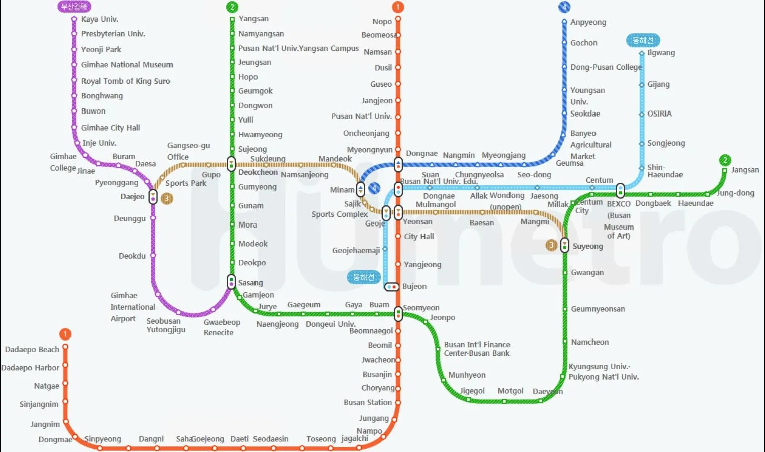
Learn the Busan subway map
Busan has Subway Lines 1 through 4, plus the Donghae Line and the Busan-Gimhae Light Rail. Visitors use Line 1 (Nampo-dong, Seomyeon, Dongnae) and Line 2 (Haeundae, Gwangalli, Seomyeon) the most — they cross at Seomyeon Station, the city's busiest transfer point.
- 2
Get and top up a transit card
Buy a Cashbee transit card at the airport or a city convenience store and top it up on the spot. It works across subway, bus, and even taxis, which is far more convenient than buying single tickets each time.
- 3
Make the most of free transfers
Transfer between bus and subway within a set window using the same card, and you won't be charged the base fare twice — just the distance-based difference. Using this system well can save a real amount on transport costs.
Busan subway lines at a glance
| Line | Color | Key stations |
|---|---|---|
| Line 1 | Orange | Nampo, Jagalchi, Seomyeon, Dongnae |
| Line 2 | Green | Seomyeon, Gwangan, Haeundae, Jangsan |
| Line 3 | Brown | Gu Nampo Market, Daejeo |
| Line 4 | Blue | Dongnae, Anpyeong |
| Busan-Gimhae Light Rail | — | Sasang, Gimhae Airport, Gaya Univ. |
Lines 1 and 2 alone cover nearly every major sight featured on this site — the two lines worth knowing well when planning your route.
Buying and using a transit card
Pick up a Cashbee card at the airport arrivals hall or a city convenience store (GS25, CU, etc.) and ask staff to top it up. It works by tap on subway, bus, and even taxis. If you have balance left before leaving Busan, you can get a refund at a convenience store (a small fee applies). Cashbee is only one option — see our transit card comparison if you want to weigh it against T-money, WOWPASS, or the Visit Busan Pass.
How the bus system works
Busan buses come in two types: regular buses (running within city districts) and seated buses (longer routes with assigned seats). Tap your card on boarding, and tap again before you get off so the system correctly calculates the transfer or distance-based fare. Some buses only announce stops in Korean, so it’s worth pairing the ride with a navigation app to confirm the stop name and when to get off.
Which navigation app to use
Google Maps doesn’t provide accurate public transit directions in Korea — no detailed bus numbers or transfer information. Use “Naver Map” or “Kakao Map” instead. Both have English interfaces and show the exact bus number, transfer stations, and estimated arrival time — essential apps for any independent trip around Busan. See our full rundown of must-have apps for Busan for translation, payment, and delivery apps too.
Related reading
Check out City Tour Bus vs. Busan City Pass to help decide whether a pass is worth adding to your trip. If you’ve just landed and are still figuring out how to get from the airport into the city, see The Complete Guide: Gimhae Airport to Downtown Busan; if you’re flying direct from southern Taiwan, start with the Kaohsiung to Busan guide. And for heavy luggage or late-night door-to-door trips, a taxi is easiest — see Busan taxis & Kakao T. Visiting in autumn? The best Busan fall-foliage spots you can reach by subway and bus are all mapped out too.
Airport Pickup Services
Visit Busan Pass (built-in T-money transit)
The easiest transit card for visitors — it works as a T-money card on every subway and bus, and also bundles free or discounted entry to 40+ Busan attractions. Book online, then just tap the QR code on arrival. Worth it if you'll ride transit a lot and hit 3+ paid sights.
WOWPASS (transit card + currency exchange)
A single card that combines a T-money transit function with on-the-spot currency exchange and a prepaid card. Feed in foreign cash at an airport or city kiosk and it loads Korean won straight onto the card — no separate exchange counter needed.
Frequently Asked Questions
What's the cheapest way to get around Busan as a tourist?
Get a rechargeable Cashbee transit card, buy it at the airport or any convenience store, and use it for subway, bus, and even taxis. Paying by card gives you free or discounted transfers between bus and subway within a set window, so you're only charged the distance difference instead of a new base fare — over a day of sightseeing that saves a meaningful amount versus single tickets.
Which subway lines do visitors use most in Busan?
Lines 1 and 2. Line 1 runs through Nampo-dong, Seomyeon, and Dongnae; Line 2 covers Haeundae, Gwangalli, and Seomyeon. They cross at Seomyeon Station, the city's busiest transfer point, so most tourist routes are some combination of these two lines.
Does a Busan transit card work on Seoul subways too?
Yes. Cashbee and T-money are accepted nationwide, so the same card works on Seoul's subway and buses, and in many other Korean cities. If you're pairing Busan with Seoul, one card covers both.
Do I need to buy a separate ticket for buses and the subway?
No — the same transit card works on both. Tap on when you board and, on buses, tap off when you exit so the free-transfer discount applies. This is the main reason a card beats single-journey tickets in Busan.
💰 Check before you book
Before you go, check the latest KKday discount codes — one code can shave a meaningful amount off your booking.
See the latest discount codes →💡 Some links on this page are affiliate links. If you complete a booking through them, we may earn a commission at no extra cost to you. Affiliate Disclosure